
antecedentes del proyecto
Localización del proyecto:El alcance del proyecto se extiende a lo largo del río Raisin desde la presa Nooney, en la desembocadura del lago Vineyard, hasta inmediatamente aguas abajo del puente Mill Street en Village of Brooklyn. El área de este proyecto está ubicada en su totalidad dentro del municipio de Columbia, condado de Jackson, Michigan.
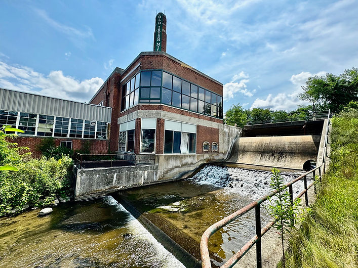
Descripción del problema:La Presa de Brooklyn (BD) está regulada por el Departamento de Medio Ambiente, Grandes Lagos y Energía (EGLE) debido a la altura y el tamaño del embalse asociado. EGLE clasifica la BD como una represa de alto potencial de peligro ya que se esperan pérdidas de vidas y se esperan impactos severos si ocurriera una falla en la represa. BD, como se ve en gran medida hoy en día, se construyó en 1939 y se utilizó para suministrar energía hidroeléctrica a la planta de fabricación adyacente. La represa ya no se usa para suministrar energía hidroeléctrica, pero estuvo en funcionamiento en 2006. La represa es una estructura de tierra con un aliviadero de concreto de 32 pies de ancho con un terraplén de tierra que se extiende 300 pies a cada lado del aliviadero. La altura máxima del terraplén es de 22,5 pies y el aliviadero es de 18 pies de altura (EGLE Dam Safety Report 2016). La evaluación del río Raisin del Departamento de Recursos Naturales de Michigan (DNR) destaca la importancia de este tramo de alto gradiente del río Raisin, cerca de Brooklyn, para su salud y la vida acuática asociada. Los peces y otros animales acuáticos suelen ser más diversos y productivos en hábitats de alto gradiente. El informe establece que la longitud total del río Raisin es de 149 millas y solo el 5% tiene un hábitat de alto gradiente que se encuentra solo en las cabeceras y se localiza en Brooklyn y tramos pequeños en Manchester y Tecumseh. Gran parte del hábitat de alto gradiente ha sido inundado por represas y sus embalses, eliminando este hábitat único y productivo y fragmentando el río, por lo que no permite que los peces se muevan libremente a través del río.
Proyecto propuesto:Eliminación de la BD de alto potencial de peligro, restauración de aproximadamente 2,600 pies del río Raisin utilizando el diseño de canal natural (NCD) a través del embalse anterior, reemplazo del puente Mill Street y construcción de rápidos de roca natural sobre la presa Nooney.
Socios y colaboración:River Raisin Watershed Council, Jackson County Drain Office, Village of Brooklyn, DNR, Michigan Department of Transportation, EGLE, US Fish & Wildlife Service, Niswander Environmental, Green Watershed Restoration y Five Smooth Stones son socios clave.
Beneficios del proyecto:La eliminación de la BD de alto potencial de peligro, la restauración de un cauce fluvial estable que funcione utilizando NCD, el reemplazo del puente de Mill Street y la construcción de rápidos de roca natural sobre la presa Nooney eliminarán de forma permanente el riesgo y las responsabilidades asociadas con la presa, mejorarán la seguridad pública, restaurarán el hábitat y Resiliencia en el río. Las actividades del proyecto proporcionarán hasta 44 millas de conectividad a los tramos de cabecera del río Raisin, lo que permitirá el movimiento diario, estacional y anual de los peces para acceder al hábitat necesario para vivir sus vidas.
Estado del proyecto:Los esfuerzos de los socios hasta la fecha incluyen el desarrollo de subvenciones para obtener los fondos necesarios para la ejecución del proyecto. El trabajo de factibilidad realizado incluye evaluación geomórfica, estudios de mejillones y peces, análisis de sedimentos y análisis de alternativas de diseño. Los próximos esfuerzos de trabajo para 2023 incluyen estudios topográficos adicionales, evaluación de humedales, investigación de servicios públicos, estudios hidráulicos e hidrológicos. La información recopilada durante el estudio de factibilidad se utilizará para desarrollar el diseño final y permitir el desarrollo.
Punto de contacto:
Meija Knafl
rrwc@lenawee.mi.us
517-264-4754
Hitos del proyecto:
Finalización del estudio de factibilidad:junio 2023
Reducción del embalse de Brooklyn:julio 2023-julio 2024
Pasaje de peces de la presa Nooney:julio 2023-julio 2024
Plano de Diseño Definitivo:octubre de 2023
Presentación del Permiso EGLE:diciembre 2023
Eliminación de presas de Brooklyn/restauración de arroyos:julio 2024
Reemplazo del puente de Mill Street:Por determinar


Regístrese para recibir actualizaciones mensuales del proyecto mediante el código QR o haciendo clic aquí .
¡Haga clic en la foto para descargar el último boletín!
Representaciones del proyecto
Estas imágenes ofrecen una visión del futuro, mostrando la apariencia anticipada del sitio del proyecto una vez finalizado.


Diez preguntas principales sobre el proyecto de conectividad de la presa de Brooklyn
A continuación se detallan las diez consultas más comunes que hemos recibido sobre el Proyecto de Conectividad de Brooklyn. Esperamos que esto ayude a arrojar algo de luz sobre el proyecto. Si tiene alguna pregunta que no ve respondida aquí, no dude en enviarnos un correo electrónico a admin@riverraisin.org .
1.
¿La presa de Brooklyn es de propiedad pública o privada?
La presa de Brooklyn es una presa de propiedad privada. Como presa de propiedad privada, el propietario de la presa es responsable del monitoreo y mantenimiento continuos mientras la presa permanezca en su lugar.
2.
¿Será necesario eliminar otras represas como resultado de la modificación de la presa de Brooklyn?
No será necesario eliminar ninguna otra presa como resultado del Proyecto de Conectividad de la Presa de Brooklyn. La determinación de eliminar o modificar una presa es decisión exclusiva del propietario de la presa.
3.
¿La modificación de la presa de Brooklyn como parte del Proyecto de Conectividad provocará inundaciones río abajo?
La modificación de la presa de Brooklyn no provocará inundaciones aguas abajo. La presa de Brooklyn funciona como una instalación de pasada, lo que significa que la cantidad de agua que ingresa al estanque es igual a la cantidad de agua que sale de la presa. La presa de Brooklyn se construyó para proporcionar energía hidroeléctrica, no para almacenar inundaciones, por lo que no tiene capacidad operativa ni de almacenamiento adecuada para proporcionar un control significativo de las inundaciones.
4.
¿Vineyard Lake verá niveles de agua más bajos con la modificación de la presa de Brooklyn?
Vineyard Lake tiene un nivel de lago legalmente establecido que ha sido establecido mediante acción judicial. Los niveles de agua en Vineyard Lake están controlados por la presa de Nooney Lake, en la desembocadura de Vineyard Lake, que pertenece y es administrada por la Oficina de Drenaje del Condado de Jackson. Dado que la presa de Brooklyn está ubicada aguas abajo de la presa Nooney, la modificación de la presa de Brooklyn no reducirá las elevaciones de la superficie del agua ni los niveles del lago Vineyard.
5.
¿Se secará el río Raisin aguas arriba de la presa de Brooklyn?
La modificación de la presa de Brooklyn como parte del Proyecto de Conectividad no provocará que el río Raisin se seque y desaparezca aguas arriba de la presa. Se seguirán recibiendo caudales del río Raisin a través de Vineyard Lake y Kedron Drain, así como de la recarga de aguas subterráneas, lo que contribuirá al flujo como todos los demás ríos naturales de Michigan.
6.
¿Brooklyn Pond se verá diferente?
El estanque de Brooklyn tendrá un aspecto diferente al actual una vez que se modifique la presa. El río Raisin a través del antiguo estanque será restaurado y una vez más será un río funcional que será más estrecho y menos profundo de lo que parece hoy. Para ayudar a conceptualizar el tamaño del río, se puede mirar el Swain Memorial Park, ya que el río será similar en tamaño.
7.
¿El antiguo estanque de Brooklyn se convertirá en una gran marisma?
El vaciado del estanque se producirá lentamente a lo largo de casi un mes. Una de las preocupaciones que muchas personas tienen con cualquier modificación de la presa es que el antiguo estanque, que está cubierto de agua, permanecerá sin vegetación y se convertirá en una marisma antiestética. Por el contrario, lo que hemos aprendido de otras demoliciones de presas es que existe un lecho de siembra muy rico en nutrientes en los sedimentos del estanque, y una vez que el agua se vacia, la vegetación exuberante suele emerger en tan solo un par de semanas. Además, para garantizar una buena cobertura vegetal, los sedimentos expuestos se sembrarán con pasto de rápido crecimiento para reducir la erosión.
8.
¿Quién será el propietario de la propiedad bajo el anterior embargo ?
En la mayoría de los casos, en Michigan, los propietarios de tierras ribereñas son propietarios del “hilo” central del canal o de la orilla del agua, aunque esto puede variar según los títulos individuales. En algunos casos, el propietario de la presa es propietario de la propiedad “inundada” cubierta por el embalse. Esto puede seguir igual cuando se retire la presa. La mejor manera de determinar la propiedad de la antigua zona del estanque es que los propietarios ribereños consulten sus títulos de propiedad individuales.
9.
¿Se espera que mejore la pesca?
Sí, se espera que la pesca mejore. El Departamento de Recursos Naturales de Michigan (MDNR) ha identificado el río Raisin en Brooklyn como un proyecto prioritario de conservación de hábitat, cuyas especies objetivo son la lobina negra y el lucio del norte. Se espera que la modificación de la presa de Brooklyn aumente la seguridad pública, el beneficio recreativo para los pescadores, kayakistas y piragüistas y la reconexión de un hábitat crítico de alta calidad. La reconexión de este sistema aborda los factores que limitan el hábitat y permite el acceso potencial de 44 millas río arriba de paso de organismos acuáticos. El MDNR identificó que la presa de Brooklyn ha eliminado y fragmentado el hábitat de peces más productivo en el río Raisin. MDNR afirma que la longitud total del río Raisin es de 149 millas, de las cuales 92 millas o 62% tienen una pendiente baja de menos de 3 pies por milla. El gradiente promedio más alto se puede encontrar desde las cabeceras hasta Tecumseh a 5,7 pies por milla. Los peces y otros animales acuáticos suelen ser más diversos y productivos en gradientes de ríos de entre 10 y 70 pies por milla. Esta clase de gradiente altamente deseable se encuentra sólo en 7,5 millas o el 5% del cauce principal en las cabeceras, una parte del cual se localiza en Brooklyn. Se espera que la pesca fluvial mejore como resultado de la modificación de las presas y la restauración de los arroyos asociados.
10.
¿Cuándo se prevé que comience el Proyecto de Conectividad?
La reducción del antiguo embalse (estanque del molino) ya está completa. Las condiciones del permiso EGLE requerían una tasa de reducción de no más de 0,5 pies por día; sin embargo, para reducir el varamiento de organismos, la movilización de sedimentos y el flujo hacia las aguas receptoras aguas abajo, la tasa de reducción se llevó a cabo durante un período de 39 días desde el 8 de agosto hasta el 18 de septiembre. de 2023, para una tasa de reducción promedio de 0,17 pies por día.
El 6 de junio de 2023, antes de la reducción, se realizó un estudio de mejillones con SCUBA en el embalse para localizar los mejillones en el embalse y luego reubicarlos. No se identificaron mejillones ni hábitat de mejillones durante el estudio SCUBA. Se realizaron inspecciones diarias del área de reducción durante todo el período de reducción. Los estudios diarios de organismos acuáticos varados se iniciaron el 8 de agosto y concluyeron el 18 de septiembre. Sin embargo, se realizaron estudios adicionales después de la conclusión de la reducción hasta el 13 de octubre de 2023. Los organismos acuáticos varados se identificaron por especies, se midieron (longitud total, mm) y fueron representativos. fotos tomadas. Los organismos fueron colocados en equipos de viaje apropiados para su reubicación. Un miembro del personal trasladó los organismos al área de reubicación para su liberación inmediata.
Calendario de reducción
Se prevé que el permiso para la reducción del embalse se emita durante la primera semana de agosto de 2023.
Calendario de reducción
Se prevé que el permiso para la reducción del embalse se emita durante la primera semana de agosto de 2023.
Monitoreo diario de organismos acuáticos varados
Mejillón Informe de la encuesta 2023
Lista de semillas


Haga clic en la foto para descargar el artículo de Exponent.