
Upper River Raisin Watershed Restoration
and Connectivity Project
Project Location: Project reach extends along the River Raisin from Nooney Dam, at the outlet of Vineyard Lake, to immediately downstream of Mill Street bridge in the Village of Brooklyn. This project area is located entirely within Columbia Township, Jackson County, Michigan.
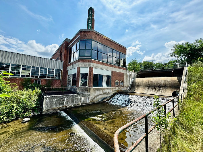
Description of Problem: The Brooklyn Dam (BD) is regulated by the Department of Environment, Great Lakes, and Energy (EGLE) due to its height and size of the associated impoundment. EGLE classifies the BD as a High Hazard Potential Dam as loss of life and severe impacts are expected if a dam failure occurred. BD as largely seen today was constructed in 1939 and was used to supply hydroelectricity for the adjacent manufacturing plant. The dam is no longer used to supply hydroelectric power but had been in operation as recently as 2006. The dam is an earthen structure with a 32-foot-wide concrete spillway with an earthen embankment which extends 300 feet to either side of the spillway. The maximum height of the earthen embankment is 22.5 feet and the spillway is 18 feet in height (EGLE Dam Safety Report 2016). The Michigan Department of Natural Resources (DNR), River Raisin Assessment highlights the importance of this high gradient reach of the River Raisin, near Brooklyn to its health and associated aquatic life. Fish and other aquatic animals are typically most diverse and productive in high gradient habitat. The report states that the total length of the River Raisin is 149 miles in length and only 5% has high gradient habitat that is found only in the headwaters and localized in Brooklyn and small reaches in Manchester and Tecumseh. Much of the high gradient habitat has been inundated by dams and their impoundments eliminating this unique and productive habitat and fragmenting the river therefore not allowing fish to freely move through the river.
Proposed Project: Removal of the High Hazard Potential BD, restoration of approximately 2,600 ft. of the River Raisin utilizing Natural Channel Design (NCD) through the former impoundment, replacement of the Mill Street bridge and construction of natural rock rapids over Nooney Dam.
Partners and Collaboration: River Raisin Watershed Council, Jackson County Drain Office, Village of Brooklyn, DNR, Michigan Department of Transportation, EGLE, U.S. Fish & Wildlife Service, Niswander Environmental, Green Watershed Restoration and Five Smooth Stones are key partners.
Project Benefits: Removal of the High Hazard Potential BD, restoration of a functioning stable river channel using NCD, replacement of Mill Street bridge and construction of natural rock rapids over Nooney Dam will permanently eliminate risk and liabilities associated with the dam, improve public safety, restore habitat and resiliency in the river. Project activities will provide up to 44 miles of connectivity to headwater reaches of the River Raisin allowing for daily, seasonal and annual fish movement to access habitat necessary to live out their lives.
Project Status: Project partners efforts to date include obtaining grants for necessary project funding, completing feasibility studies, and ongoing environmental analyses and alternative design analyses.
Upcoming project work includes finalizing design plans, submitting EGLE permits, conducting floodplain modeling, and continuing community outreach and engagement.
Project Milestones:
Feasibility Study - Completed July 2023
Brooklyn Impoundment Drawdown – Completed October 2023
Final Design Plans – January 2025
EGLE Permit Submittal – February 2025
Mill Street Bridge Replacement - Winter 2025
Nooney Dam Fish Passage – Summer 2026
Brooklyn Dam Removal/Stream Restoration - Summer 2026


Sign Up For Monthly Project Updates by QR Code or by clicking here.
Click on the photo to download the latest newsletter!
Project Renderings
These images offer a glimpse into the future, showcasing the anticipated appearance of the project site upon completion.


Top Ten Questions About the Brooklyn Dam Connectivity Project
Below are the top ten common inquiries we've received about the Brooklyn Connectivity Project. We hope these will help shed some light on the project. If you have a question that you don't see answered here feel, free to email us at admin@riverraisin.org.
1.
Is Brooklyn Dam publicly or privately owned?
Brooklyn Dam is a privately owned dam. As a privately owned dam, the dam owner is responsible for ongoing monitoring and maintenance as long as the dam remains in place.
2.
Will other dams be required to be removed as a result of the modification of the Brooklyn Dam?
No other dams will be required to be removed as a result of the Brooklyn Dam Connectivity Project. The determination to remove or modify a dam is solely the decision of the dam owner.
3.
Will modification of the Brooklyn Dam as a part of the Connectivity Project result in downstream flooding?
Modification of the Brooklyn Dam will not result in downstream flooding. The Brooklyn Dam is operated as a run of river facility which means that the amount of water that enters the pond is equal to the amount of water leaving at the dam. The Brooklyn Dam was built to provide for hydroelectric power, not for flood storage, therefore does not have adequate storage or operational capability to provide for significant flood control.
4.
Will Vineyard Lake see lower water levels with the modification of Brooklyn Dam?
Vineyard Lake has a legally established lake level that has been established by court action. Water levels in Vineyard Lake are controlled by the Nooney Lake Dam, at the outlet of Vineyard Lake, which is owned and managed by the Jackson County Drain Office. Since the Brooklyn Dam is located downstream of Nooney Dam, the modification of the Brooklyn Dam will not reduce water surface elevations or lower lake levels at Vineyard Lake.
5.
Will the River Raisin dry up upstream of Brooklyn Dam?
Modification of the Brooklyn Dam as part of the Connectivity Project will not result in the River Raisin drying up and disappearing upstream of the dam. Flows will continue to be received from the River Raisin through Vineyard Lake and Kedron Drain, as well as groundwater recharge, which will contribute to flow just like all other naturally occurring rivers in Michigan.
6.
Will Brooklyn Pond look different?
The Brooklyn Pond will look differently than it does today once the dam is modified. The River Raisin through the former pond will be restored and once again be a functioning river which will be narrower and shallower than it appears today. To help conceptualize the size of the river, one can look to Swain Memorial Park as the river will be similar in size.
7.
Will the former Brooklyn Pond be a big mudflat?
The pond draw-down will occur slowly over nearly a month of time. One of the concerns that many people have with any dam modification is that the former pond, that is covered in water, will remain unvegetated and remain an unsightly mudflat. On the contrary, what we have learned from other dam removals is that there is a very rich seedbed in the nutrient rich pond sediments and once the water is drawn down, lush vegetation typically emerges within just a couple of weeks. In addition, just to ensure there is good vegetative coverage the exposed sediments will be seeded with a rapidly emerging and fast-growing grass to reduce erosion.
8.
Who will own the property under the former impoundment?
Most often in Michigan riparian land owners own to the center “thread” of the channel or to the water’s edge although this can vary based on individual deeds. In some cases, the dam owner owns the “flooded” property covered by the impoundment. This may remain the same when the dam is removed. Ownership of the former pond area can best be answered by riparian owners consulting their individual property deeds.
9.
Is fishing expected to improve?
Yes, fishing is expected to improve. The Michigan Department of Natural Resources (MDNR) has identified the River Raisin in Brooklyn as a Priority Habitat Conservation Project with target species being smallmouth bass and northern pike. Modification of the Brooklyn Dam is expected to increase public safety, recreational benefit for anglers/kayakers/canoeist and reconnection of high-quality critical habitat. Re-connection of this system addresses habitat limiting factors and allows for the potential access of 44 upstream miles of aquatic organism passage. The MDNR, identified that the Brooklyn Dam has eliminated and fragmented the most productive fish habitat in the River Raisin. MDNR states that, the total length of the River Raisin is 149 miles with 92 miles or 62% being low gradient at less than 3 feet per mile. The highest average gradient can be found from the headwaters to Tecumseh at 5.7 feet per mile. Fish and other aquatic animals are typically most diverse and productive in river gradients between 10 and 70 feet per mile. This highly desirable gradient class is found only in 7.5 miles or 5% of the main stem in the headwaters a portion of which is localized in Brooklyn. River fisheries are expected to improve as a result of dam modification and associated stream restoration.
10.
When is the Connectivity Project anticipated to begin?
The drawdown of the former impoundment (mill pond) is now complete. EGLE permit conditions required a drawdown rate of no more than 0.5 ft. per day, however, to reduce organism stranding, sediment mobilization and flow to downstream receiving waters the rate of drawdown was conducted over a 39-day period from August 8 through September 18, 2023, for an average drawdown rate of 0.17 ft. per day.
SCUBA mussel survey was conducted in the impoundment on June 6, 2023, prior to the drawdown, to locate any mussels in the impoundment to then be relocated. No mussels or mussel habitat was identified during the SCUBA survey. Daily inspections of the drawdown area were conducted during the entire drawdown period. Daily stranded aquatic organism surveys were initiated on August 8 and concluded on September 18. However, additional surveys were conducted after conclusion of the drawdown through October 13, 2023. Stranded aquatic organisms were identified to species, measured (total length, mm) and representative photos taken. Organisms were placed into appropriate travel equipment for relocation. A staff member relocated the organisms to the relocation reach for immediate release.
Drawdown Schedule
Vineyard Lake - Nooney Dam WSL
Daily Stranded Aquatic Organism Monitoring
Mussel Survey Report 2023
Seed List


Click photo to download the Exponent article.